Project Zero30
Zero30 will achieve certification of the Armidale Local Government Area through the Climate Active Carbon Neutral Standard for Precincts. The Climate Active Carbon Neutral Standard will help us to manage our greenhouse emissions and achieve our goal of carbon neutrality by 2030.
Zero30 is a collaboration between the Armidale Regional Council, the University of New England, Business New England and the broader regional community in NSW, Australia. My role is as a postdoctoral research fellow in Zero30 project to qunatify greenhouse accounts as precinct. Please read more on this project here.

Soil carbon of agricultural systems
Typology of rice-based cropping systems for improved soil carbon management: Capturing smallholder farming opportunities and constraints in Dinajpur, Bangladesh
Abstract: Characterization of smallholder land resource endowment and cropping practice can assist in the implementation of a more tailored approach to Soil Carbon Management (SCM). Land resource and cropping practice data, stratified by soil physiography, was collected through a survey involving 83 farmers in four upazila of Dinajpur district, Bangladesh. The aim was to determine a farming system typology based on smallholder land resource endowment and cropping practices, and to consider the likelihood of soil carbon improvement under the typology. A Cluster Analysis was performed using data on seven variables that combined land resource (physiography, land type, landholding, farm size) and cropping practice (cropping system, cropping intensity, crop rotation) characteristics to determine a farming system typology. The resulting typology, referred to as Soil Carbon Improvement Likelihood (SCIL), identified three different farming system types. These were then assessed with regard to their potential for improving soil carbon in these systems. The most prevalent SCIL, Medium SCIL (Type 1, 42%) consists of the maize-rice, wheat-rice and veg.-rice cropping systems in the HL areas of the Piedmont plain, Floodplain and Terrace. It is managed with high fertilization, low crop rotation and low to medium crop residue retention. The next most prevalent SCIL, Low SCIL (Type 3, 30%) consists of a rice-rice cropping system in the HL and MHL areas of the Piedmont plain, Floodplain and Terrace, and is managed with medium fertilization, no crop rotation and limited residue retention. The least prevalent farming system type, the High SCIL (Type 2, 28%) consists of crop-diversified and mustard-rice cropping systems in the MHL areas of the Floodplain and Terrace, which is managed with high fertilization, crop rotation and high crop residue retention. This study showed that cropping systems with higher crop intensification and high retention of crop residue, on the Floodplain soil physiography and MHL land inundation type, provide the greatest opportunity for improved SCM, but were represented by less than one-third of the farmers (n = 20) in this survey. These farmers were also mainly private landholders. The typology presented here can potentially serve as a practical framework for delineating cropping systems and management under particular land resource settings to undertake more targeted innovations and SCM priorities in Rice-based Cropping Systems. Read Article Here
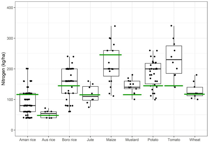
Fig. 5. Farmers' rates of N fertilizer use on crops. The green lines represent the maximum recommended rates of fertilizer use against the yield goals (Table 5) according to Hassan et al. (2012), where soil fertility status for N is considered low. The black dots in each boxplot represent the rates of fertilizer use of the surveyed farmers (n = 83). The horizontal black line in each boxplot shows the median, boxes show the first and third quartiles, and the whiskers extend to the minimum and maximum beyond the interquartile range.
|
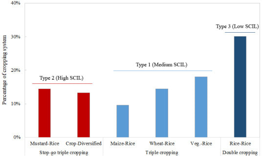
Fig. 7. Proportion of farmers categorized by Soil Carbon Improvement Likelihood (SCIL): High SCIL, Medium SCIL and Low SCIL in the cropping systems under cropping intensity (n = 83).
|
National legacy soil datasets
Temporal Variations of Soil Organic Carbon and pH at Landscape Scale and the Implications for Cropping Intensity in Rice-Based Cropping Systems
Abstract: Landscape scale assessment of temporal variations in soil organic carbon (SOC) contents and soil pH and the implications for long-term agricultural sustainability was determined using legacy datasets collected over two periods separated by 20 years: the 1990s and 2010s. Soil data on SOC and pH were categorized according to the prevailing land types (based on inundation as highland (HL), medium highland (MHL), and medium lowland (MLL)), and physiographic types (i.e., Himalayan Piedmont plain, Tista Floodplain and Barind tract/Terrace) to determine which variable or combination of variables was more influential in spatial and temporal changes of these properties. SOC contents in the physiographic types were generally found to be low, varying between 8 to 12 g/kg. While, SOC contents were significantly higher in MHL and MLL compared with HL that experienced less inundation. The change in SOC contents over 20 years was significant with a 14.5% increase of SOC. There was a greater influence of land type compared with physiography on SOC contents over time. Inundation land types and associated cropping intensity were considered likely to influence SOC of soils under rice-based cropping systems. Furthermore, the levels of soil pH decreased by 0.5 units over 20 years with an approximately 50% increase in soils within a pH category of 4.6–5.5. The majority of soil pH results shift from slightly acidic to strongly acidic in the intervening 20-year period between samplings. Soil acidification is potentially a combination of inefficient and excess use of ammonium-based fertilizers with higher application rates and low input from residues. We conclude that acidification may continue with more intensive land use. However, trends in SOC contents over time under certain combinations of physiography and land type either increased slightly or showed a significant loss and in the latter, specifically, the role of land management is not clear. The legacy datasets would be useful for monitoring spatial and temporal soil quality trends at a regional scale, but has limited capacity to capture field level variations in soil properties as data on smallholder cropping practice and management were not collected. Therefore, future research examining the role of management in SOC and pH dynamics at the field-scale would guide the use of fertilizers, crop residue management, and amelioration of acidic soil, to improve the sustainability of rice-based cropping systems in Bangladesh. Read Article Here
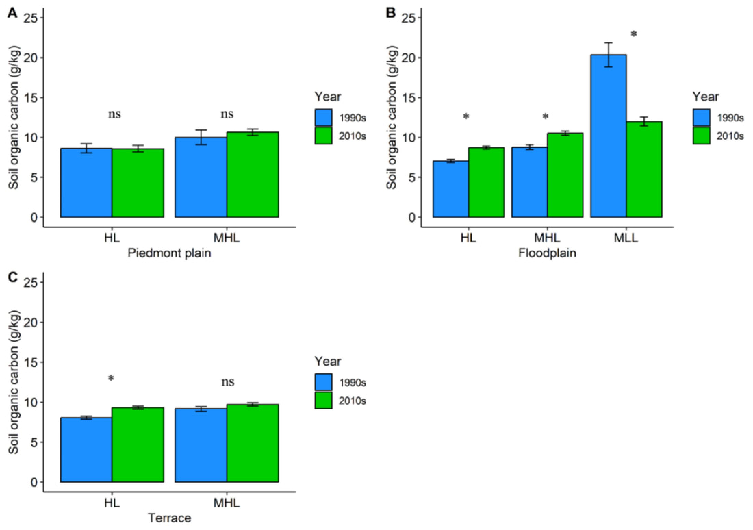
Figure 5. Soil organic carbon (SOC) contents (0–15 cm) across land types sampled in 1990s and 2010s in the (A) Piedmont plain, (B) Floodplain and (C) Terrace physiography. The error bars represent respective standard errors. The significant difference is indicated by ‘*’ and non-significant difference is indicated by ‘ns’ sign.
|
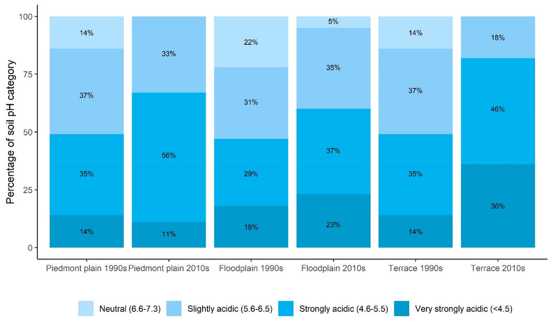
Figure 9. Percentage of soil pH (0–15 cm) category in legacy soil samples collected in the 1990s and 2010s in three physiography. The legend consists of the pH categories [33] in Bangladesh.
|
Soil mapping: electromegnatic induction (EM38)
Potential of soil sensor EM38 measurements for soil fertility mapping in the Floodplain and Terrace soil of Bangladesh
Abstract: An assessment of the field-scale variation of apparent electrical conductivity (ECa) survey and the characterization of correlated soil property was investigated for mapping of a terrace and a floodplain soil of Bangladesh. The electromagnetic induction (EMI) technique was applied by a soil sensor, EM38 which provide ancillary ECa data sets accurately. The survey was supported by soil sampling to assure the reliability and to make evident the potential of ECa measurements for soil mapping. The soils of the study sites greatly differed, the terrace site consisted of a shallow depth clay substratum and the floodplain site bears a sandy substratum. The ECa readings in mS m-1 ranged from 40 to 64 and 32 to 53 in the vertical (ECa-V) and horizontal (ECa-H) orientation of measurement respectively in the terrace site. In the floodplain site, ECa readings in mS m-1 ranged from 35.1 to 50.8 and 33.8 to 47.4 for the ECa-H and ECa-V respectively. In the terrace site, the ECa readings correlated best with soil property such as top-, sub-, and deepsoil texture (clay and sand), and topsoil chemical property, i. e., pH, CEC, Ca2+ and Mg2+. For the floodplain site, the ECa readings correlated best with top- and deepsoil texture, and topsoil organic C. A modest correlation was found between ECa-V and the subsoil clay (r = 0.78), and ECa-V and the subsoil sand (r = - 0.84) in the terrace site. In the floodplain site, the correlation between ECa-H and topsoil clay was the highest (r = 0.66). The variogram analysis revealed that a large portion of the total variation of soil property (about 70 %) was accounted by the spatially structured component of the variogram. The study findings have brought an expectation that soil mapping through ECa measurement is possible in Bangladesh. For mapping, the ECa-V measurement in the terrace soil is more predictive than ECa-H while the ECa-H measurement in the floodplain soil is more predictive than ECa-V. The maps of ECa can fairly represent the spatial variation of soil properties. Thus provide useful information on soil texture, chemical fertility and organic matter content. The ECa map also provides a means of monitoring the spatial variation of soil properties that potentially influence the crop production. The ECa maps can also guide directed soil sampling with the purpose of updating the existing soil maps of Bangladesh. Read More
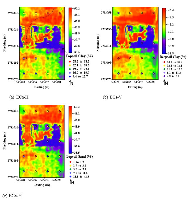
Figure 24. Interpolated values in mS m-1 for the ECa-H with a) topsoil clay and c) sand, and the ECa-V with b) deepsoil clay contents superimposed on the maps in the floodplain site.
|
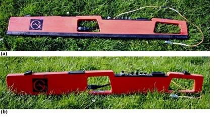
Figure 3. Pictures of EM38 soil sensor, a) ECa-H orientation and b) ECa-V orientation.
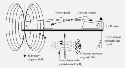
Figure 4. Diagram showing operation of electromagnetic induction based EM38 soil sensor (Robinson et. al., 2004).
|
Scientific officer: Soil Resource Development Institute
In the Bangladeshi government Ministry of Agriculture from July 2005, I worked on a variety of agricultural development projects, including regional semi-detail land surveys in the Floodplain, Barind tract and Himalayn piedmont plain, and report preparation with soil maps, field soil investigation (soil series/soil profile), land use and land management, soil fertility and soil health monitoring, fertilizer use and recommendation, demonstration of trails and field days, climate change mitigation and adaptation, soil characteriszation using precision technologies (EM38), landholders/farmers survey, focus group discussion, acted as resource person in trainings, and research-extension advisory services to the stakeholders and farmers.
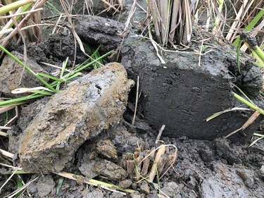
Amnura soil series in Dinajpur
|
|